
MEDIA ADVISORY
News Release
TSX:TLO
TALON METALS INTERSECTS 2.71 METERS (8.9 FEET) OF SHALLOW MINERALIZATION GRADING 5.13% NICKEL OUTSIDE OF THE COMPANY’S CURRENT RESOURCE AREA
Road Town, Tortola, British Virgin Islands (December 15, 2020) – Talon Metals Corp. (“Talon” or the “Company”) (TSX: TLO) is pleased to provide an update on the Tamarack Nickel-Copper-Cobalt Project (“Tamarack Project”), located in Minnesota, USA. The Tamarack Project comprises the Tamarack North Project and the Tamarack South Project.
HIGHLIGHTS
- Drill hole 20TK0271 intersected 2.71 meters (8.9 feet) of massive sulphide mineralization grading 5.13% Ni, included in a wider zone of mineralization of 9.55 meters (31.3 feet) grading 2.12% Ni.
- The mineralization is shallow, starting at only 242.84 meters, and is located outside of the Company’s current resource area.
- This massive sulphide was successfully identified by running a Borehole Electromagnetic (“BHEM”) survey down a previous nearby drill hole (drill hole 20TK0266). BHEM continues to be the most successful geophysical tool for identifying new high-grade massive sulphides at the Tamarack Project.
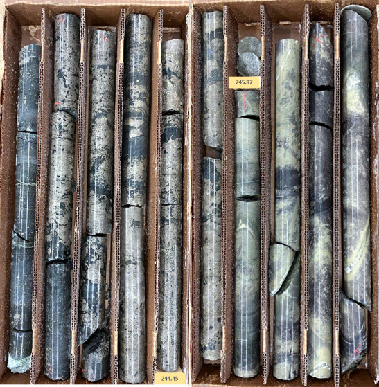
Figure 1: 2.71 meters (8.9 feet) of massive sulphide mineralization grading
5.13% nickel starting at 242.84 meters (Drill hole 20TK0271)
“So far, drilling outside of our resource area is proving to be a success”, said Brian Goldner, Head of Exploration for the Company (on secondment from Kennecott Exploration). “The mineralization is being intersected at depths much shallower than within our resource area, at grades that continue to be quite high. Over the course of January through to April we will endeavour to drill this area out aggressively, with the goal of delineating a resource so we can add to our overall tonnage.”
“These drill results show that we now understand the signature that we are chasing in this zone to the north of our resource area,” said Talon Geophysicist Brian Bengert. “Now that we are running this portable low-frequency borehole electromagnetic survey system with our own highly skilled and creative in-house crew, we are well positioned to map the thicker sulphides of this zone and beyond. We are all very excited to turn these tools loose along the 18-kilometer trend of the Tamarack Intrusive Complex.”
SUMMARY
Talon has continued exploration in an area that lies outside of its current resource area, referred to as the “CGO East” area, with drilling starting approximately 350 meters north-east of the Company’s current resource area. The CGO East is a large area with the potential to host shallow, wide sheets of mineralization that may stretch over an area of 500 meters (east-west) by 900 meters (north-south) (see the Company’s press release dated November 2, 2020 for further details).
Upon drilling holes 20TK0266 and 20TK0267 in the CGO East area, which intersected 44.75 meters (146.8 feet) and 24.69 meters (81 feet) of sulphide mineralization, respectively, Talon’s in-house geophysical team conducted a BHEM survey down each hole, which produced two off-hole BHEM anomalies (see Figure 2).
- The BHEM anomaly from drill hole 20TK0266 was used to identify and target new drill hole 20TK0271 and resulted in a thicker intercept of massive sulphide mineralization compared to drill hole 20TK0266. Drill hole 20TK0271 assayed 2.12% Ni, 0.97% Cu, 0.06% Co, 0.14 g/t Pd, 0.28 g/t Pt, and 0.23 g/t Au (2.71% NiEq[1] or 7.22% CuEq[2]) over 9.55 meters (31.3 feet) starting at 236 meters, including a high-grade 2.71 meter (8.9 feet) thick massive sulphide grading 5.13% Ni, 1.70%Cu, 0.16%Co, 0.20 g/t Pd, 0.35g/t Pt, and 0.21g/t Au (6.15% NiEq or 16.41% CuEq) starting at 242.84 meters (see Table 1).
- The BHEM off-hole anomaly from drill hole 20TK0267 has not yet been tested.
Talon’s ability to conduct BHEM surveying in-house has significantly reduced costs and has allowed for continuous surveying to take place over the Tamarack Project’s many historic open holes. The sensitivity of the new BHEM tool that is being utilized has increased the ability for Talon to find the thicker portions of a given massive sulphide unit that previously would not have been identified.
[1] NiEq% = Ni%+ Cu% x $3.00/$8.00 + Co% x $12.00/$8.00 + Pt [g/t]/31.103 x $1,300/$8.00/22.04 + Pd [g/t]/31.103 x $700/$8.00/22.04 + Au [g/t]/31.103 x $1,200/$8.00/22.04
[2] CuEq% = Cu%+ Ni% x $8.00/$3.00 + Co% x $12.00/$3.00 + Pt [g/t]/31.103 x $1,300/$3.00/22.04 + Pd [g/t]/31.103 x $700/$3.00/22.04 + Au [g/t]/31.103 x $1,200/$3.00/22.04
It is believed that within the sheet-like mineralization of the CGO East area, a mineralized channel forms where thicker intervals of basal massive sulphides have been observed and interpreted (see Figure 2 below). In cross-section, drill holes 13TK0197 (historical hole), 20TK0266 (new hole), 20TK0271 (new hole) and drill hole 03L013 (historical hole) suggest a potential mineralization width of approximately 110 meters (361 feet) across the trend (see Figure 3 below). In a longitudinal section, drilling has so far demonstrated 150 meters (492 feet) of strike-length of the 800 meter strike-length potential (see Figure 4 below).
These untested BHEM plates will make up a portion of the upcoming drilling campaign in an effort to expand the shallow high-grade intercepts shown in drill hole 20TK0271 throughout the prospective area outlined in Figure 2 below in blue.
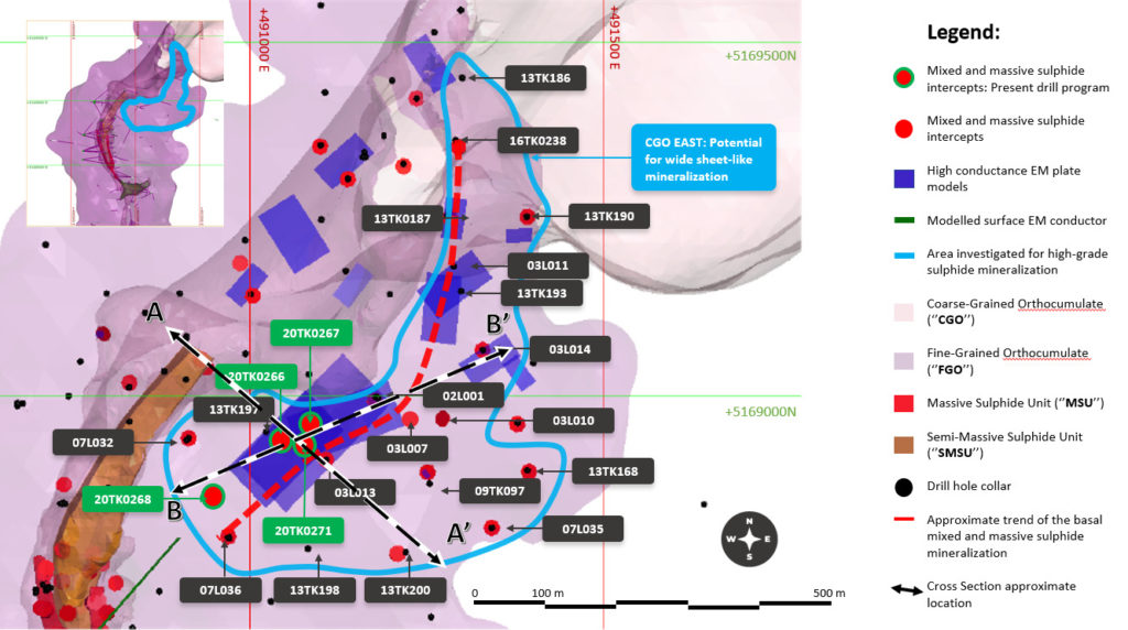
Figure 2: Plan view map of the CGO East mineralization. The purple rectangles represent the high conductance BHEM plate models.
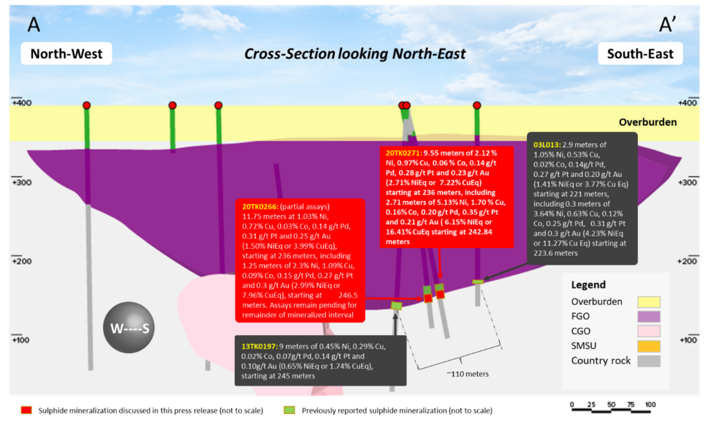
Figure 3: Cross-section looking North-East of the CGO East area. The sulphide mineralization is located at the footwall of the Fine-Grained Orthocumulate (FGO) and the country rocks meta-sediments.
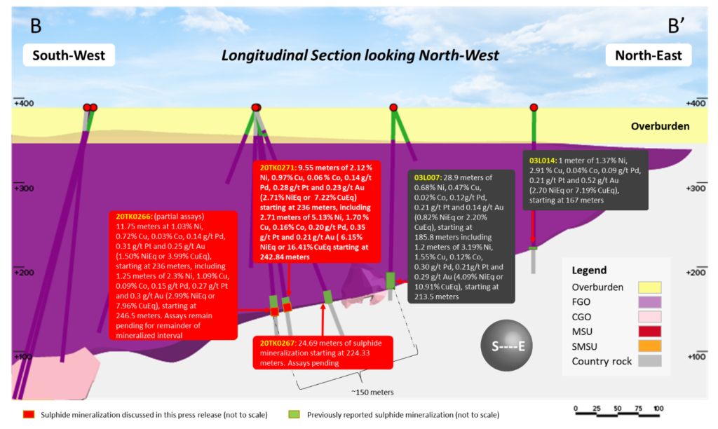
Figure 4: Longitudinal section looking North-West of the CGO East area. The sulphide mineralization is located at the footwall of the Fine-Grained Orthocumulate (FGO) and the country rocks meta-sediments.
Table 1: Summary of Drilling Results – CGO East mineralization
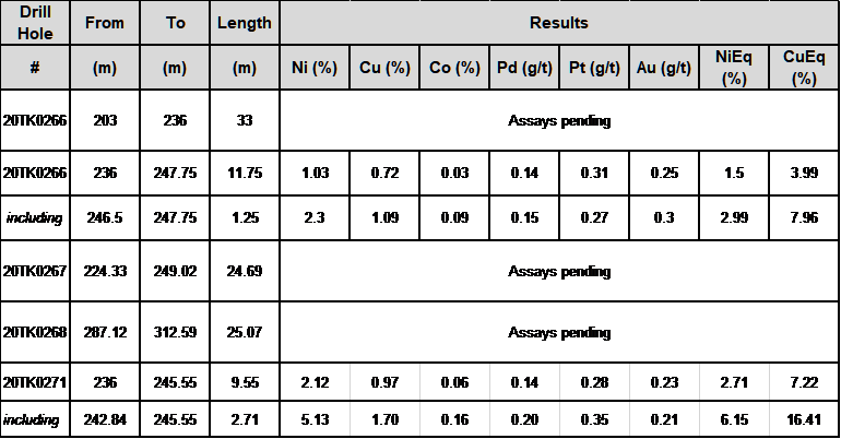
Length refers to drill hole length and not True Width.
True Width is unknown at the time of publication.
All samples were analysed by ALS Minerals. Nickel, copper, and cobalt grades were first analysed by a 4-acid digestion and ICP AES (ME-MS61). Grades reporting greater than 0.25% Ni and/or 0.1% Cu, using ME-MS61, trigger a sodium peroxide fusion with ICP-AES finish (ICP81). Platinum, palladium and gold are initially analyzed by a 50g fire assay with an ICP-MS finish (PGM-MS24). Any samples reporting >1g/t Pt or Pd trigger an over-limit analysis by ICP-AES finish (PGM-ICP27) and any samples reporting >1g/t Au trigger an over-limit analysis by AAS (Au-AA26).
NiEq% = Ni%+ Cu% x $3.00/$8.00 + Co% x $12.00/$8.00 + Pt [g/t]/31.103 x $1,300/$8.00/22.04 + Pd [g/t]/31.103 x $700/$8.00/22.04 + Au [g/t]/31.103 x $1,200/$8.00/22.04
CuEq% = Cu%+ Ni% x $8.00/$3.00 + Co% x $12.00/$3.00 + Pt [g/t]/31.103 x $1,300/$3.00/22.04 + Pd [g/t]/31.103 x $700/$3.00/22.04 + Au [g/t]/31.103 x $1,200/$3.00/22.04
Table 2: Collar Locations in the CGO East Area
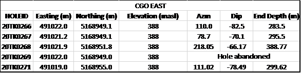
Collar coordinates are UTM Zone 15N, NAD83.
Azimuths and dips are taken from survey record at collar unless otherwise noted
Quality Assurance, Quality Control and Qualified Persons
Please see the technical report entitled “NI 43-101 Technical Report Updated Preliminary Economic Assessment (PEA) of the Tamarack North Project – Tamarack, Minnesota” with an effective date of March 12, 2020 prepared by independent “Qualified Persons” (as that term is defined in National Instrument 43-101 (“NI 43-101”) Leslie Correia (Pr. Eng), Andre-Francois Gravel (P. Eng.), Tim Fletcher (P. Eng.), Daniel Gagnon (P. Eng.), David Ritchie (P. Eng.), Oliver Peters (P. Eng.), Christine Pint (P.G.) and Brian Thomas (P. Geo.) for information on the QA/QC, analytical and testing procedures at the Tamarack Project. Copies are available on the Company’s website (www.talonmetals.com) or on SEDAR at (www.sedar.com). The laboratory used is ALS Minerals who is independent of the Company.
Lengths are drill intersections and not necessarily true widths. True widths cannot be consistently calculated for comparison purposes between holes because of the irregular shapes of the mineralized zones. Drill intersections have been independently selected by Talon. Drill composites have been independently calculated by Talon. The geological interpretations in this news release are solely those of the Company.
The locations and distances highlighted on all maps in this news release are approximate.
Dr. Etienne Dinel, Vice President, Geology of Talon, is a Qualified Person within the meaning of NI 43-101. Dr. Dinel is satisfied that the analytical and testing procedures used are standard industry operating procedures and methodologies, and he has reviewed, approved and verified the technical information disclosed in this news release, including sampling, analytical and test data underlying the technical information.
About Talon
Talon is a TSX-listed base metals company in a joint venture with Rio Tinto on the high-grade Tamarack Nickel-Copper-Cobalt Project located in Minnesota, USA, comprised of the Tamarack North Project and the Tamarack South Project. Talon has an earn-in to acquire up to 60% of the Tamarack Project. The Tamarack Project comprises a large land position (18km of strike length) with numerous high-grade intercepts outside the current resource area. Talon is focused on expanding its current high-grade nickel mineralization resource prepared in accordance with NI 43-101; identifying additional high-grade nickel mineralization; and developing a process to potentially produce nickel sulphates responsibly for batteries for the electric vehicles industry. Talon has a well-qualified exploration and mine management team with extensive experience in project management.
For additional information on Talon, please visit the Company’s website at www.talonmetals.com or contact:
Sean Werger
President
Talon Metals Corp.
Tel: (416) 361-9636 x102
Email: werger@talonmetals.com
Forward-Looking Statements
This news release contains certain “forward-looking statements”. All statements, other than statements of historical fact that address activities, events or developments that the Company believes, expects or anticipates will or may occur in the future are forward-looking statements. These forward-looking statements reflect the current expectations or beliefs of the Company based on information currently available to the Company. Such forward-looking statements include statements relating to the timing and results of the exploration program, including assay results, grades,drilling plans and geophysics; the potential to delineate an additional resource and add overall tonnage to the Company’s resource; and the potential for the CGO East area to host shallow, wide sheets of mineralization that may stretch over an area of 500 meters (east-west) by 900 meters (north-south) which may include thicker intervals of basal massive sulphides. Forward-looking statements are subject to significant risks and uncertainties and other factors that could cause the actual results to differ materially from those discussed in the forward-looking statements, and even if such actual results are realized or substantially realized, there can be no assurance that they will have the expected consequences to, or effects on the Company.
Any forward-looking statement speaks only as of the date on which it is made and, except as may be required by applicable securities laws, the Company disclaims any intent or obligation to update any forward-looking statement, whether as a result of new information, future events or results or otherwise. Although the Company believes that the assumptions inherent in the forward-looking statements are reasonable, forward-looking statements are not guarantees of future performance and accordingly undue reliance should not be put on such statements due to the inherent uncertainty therein.